Kathmandu (
Nepali:
काठमांडौ [kɑːʈʰmɑːɳɖuː];
Nepal Bhasa:
येँ द्ये) is the
capital and largest
metropolitan city of
Nepal. The city is the urban core of the
Kathmandu Valley in the Himalayas, which also contains two sister cities:
Patan or Lalitpur, 5 kilometres (3.1 mi) to its southeast (an ancient city of fine arts and crafts) and
Bhaktapur or Bhadgaon, 14 kilometres (8.7 mi) to its east (city of devotees). It is also acronymed as 'KTM' and named 'tri-city'.
[4] Kathmandu valley is only slightly smaller than Singapore in terms of area.
The city stands at an elevation of approximately 1,400 metres (4,600 ft) in the bowl-shaped valley in central Nepal surrounded by four major mountains, namely: Shivapuri, Phulchowki, Nagarjun and Chandragiri. It is inhabited by 3,949,486 (2011) people. The Kathmandu valley with its three districts including
Kathmandu District accounts for a population density of only 97 per km
2 whereas Kathmandu metropolitan city has a density of 13,225 per km
2. It is by far the largest urban agglomerate in Nepal, accounting for 20% of the urban population in an area of 5,067 hectares (12,520 acres) (50.67 square kilometres (19.56 sq mi)).
[5][6][7][8]Kathmandu is not only the capital of the Federal Democratic Republic of Nepal but also the headquarters of the Central Region (Madhyamanchal) among the five development regions constituted by the 14 administrative zones of Nepal located at the central part of the country. The Central region has three zones namely,
Bagmati,
Narayani and
Janakpur. Kathmandu is located in the
Bagmati Zone.
[9]Kathmandu, as the gateway to Nepal Tourism, is the nerve centre of the country’s economy. With the most advanced infrastructure among urban areas in Nepal, Kathmandu's economy is tourism centric accounting for 3.8% of the GDP in 1995–96 (had declined since then due to political unrest but has picked up again).
The city’s rich history is nearly 2000 years old, as inferred from an inscription in the valley. Its religious affiliations are dominantly
Hindufollowed by
Buddhism. People of other religious beliefs also live in Kathmandu giving it a cosmopolitan culture.
Nepali is the common language of the city, though many speak the
Nepal Bhasa Newari as it is the center of the
Newar (meaning: citizens of Nepal) people and culture.
English and
Hindi are understood by all of the educated population of the city. Besides a significant number of the population speaks any of the foreign languages like : French, German, Chinese, Hebrew, Korean etc. The literacy rate is 98% in the city.
[6]Kathmandu is now the premier cultural and economic hub of Nepal and is considered to have the most advanced infrastructure among urban areas in
Nepal. From the point of view of tourism, economy and cultural heritage, the sister cities of
Patan(lalitpur) and
Bhaktapur are integral to Kathmandu. Even the cultural heritage recognition under the World Heritage list of the
UNESCO has recognized all the monuments in the three urban agglomerates as one unit under the title “
Kathmandu Valley-
UNESCO World Heritage Site.
[10][11]Ancient history
The history of the city of Kathmandu, which is inseparable from that of the Kathmandu valley, dates back to ancient times.
[13] Archaeological explorations indicate that Kathamandu and the two other sister towns in the valley were the oldest towns and are traced to the period between 167 BC and 1 AD. Excavations conducted at Hadigaon and Lubhu in southern part of the valley, in Kathmandu, have unearthed brick walls and stone age tools.
The Buddha was also born in 563 B.C in the
Kapilvastu District of Nepal near the Indian border.

Rani Pokhari(Queen Pond) temple and Ghantaghar(hour house) are at the heart of Kathmandu
In 1992, workers digging a trench for the foundation of
a house in Maligaon in Eastern Kathmandu discovered a life size (171 x 49 cm) standing male figure carved in pale sandstone, clearly made in the
Kushanstyle. The sculpture was donated by an early Licchavi or pre-Licchavi monarch, named Jaya Varman with an inscription on the pedestal. Although the identity of the figure is contested, it is the authors'
[who?] opinion that it is likely Jaya Varman himself who is portrayed. It is the oldest known inscription from the Kathmandu Valley. "The inscription on this sculpture, clearly dated to samvat 107, most likely corresponding to AD 185, provides this previously missing evidence, and pushes back the epigraphical documentation of royal rule in the Kathmandu valley nearly three hundred years."
[14]The geological setting of the valley points to the existence of a lake near Chobar gorge on the
Bagmati River, below the present
Pashupatinath Temple, which was a pilgrimage place during the period of the Buddha.
[15] This lake was drained by
Manjushree Bodhisatva, a Buddhist saint, by cutting open an outlet in the southern rim of the valley. As a result the valley that was created was fertile and people started cultivating here and building their homes here. As the valley grew, Manjushree is said to have worshipped Swayambhu on the hillock where the present Swayambhu temple is located.
[15] He also founded the city of Manjupatan, which today lies within the present Kathamandu Metropolitan area, located between
Swayambu and
Gujeswari near the airport. He even declared his disciple Dharmakarma as the ruler of that city.
[13][15]Following establishment of this city, it is said that Krakuchanda Buddha, Kanak Muni Buddha and Kashyapa Buddha visited the Kathmandu valley to worship Swayambhu and Gujeshwari. Prachanda Deva, King of Gaur (
Bengal) built the Swayambu stupa encasing the eternal flame and his nephew Gunakadeva was anointed as the King of Nepal. The last ruler of his dynasty, Singhakhetu, brought prosperity to the kingdom. Subsequent to the rule of the Gunakadeva dynasty rulers from India ruled Kathmandu. Dharma Dutta of
Kanchipuram in
Tamil Nadu is cited as the builder of the
Pashupatinath Temple in Kathmandu.
[15] This was followed by the reign of
Abhir dynasty (of cowherds) of eighth rulers and the
Kiratis said to be originally of the northeastern hill region of India (700 BC). Their succession of 29 rulers reigned here until the
Lichhavis came into power.
[15]Four
stupas around the city of Patan, near Kendra Hiranyavarna Mahavihara (called "Patukodon"), 5 kilometres (3.1 mi) away from Kathmandu, is said to have been erected by
Charumati, attests to the ancient history.
[13][edit]Licchavi Kingdom (400–750)
During the reign of the
Licchavi (clan) (400–750 AD), two adjoining settlements, Yambu or Thahne (‘Yambu’ in Nepal Bhasa means the field of Kathmandu and Thahne means “northern land") and Yangal/Kone (‘Yangal’ in Nepal Bhasa means the depressed area of Kathmandu, Kone means “southern land") formed Kathmandu, also known as Koligram. Koligram is believed to be settlement of
Koliyas, some of whom migrated to Kathmandu valley after
Mahajanapadaera.
[16] Yambu is the area north of present-day Makhan Tole, next to
Durbar Square. The southern sector, called Yangal, is also known as Dakshin Koligram; and a neighborhood by this name (Yengal) exists in the city today.
[13] The Licchavi king Gunakamadeva founded a city in between these two settlements on the bank of Bishnumati river called Kantipur. The city was formed in the shape of a
Chandrahrasa (Manjushri's sword) mentioned in
Swayambhu Purana,
[17]which was used to drain Nagdaha to create the Kathmandu valley and fortified with 8 barracks which were guarded by
Ajimas. According to folklore, Gunakamadeva dreamt of being asked to found a city by Laxmi (or Kanti),
[18] so the city was formed in her name, Kantipur. According to
Nepal Sambat, the city is believed to have been founded on the auspicious date of Yenya Punhi, with the founding stone laid by Gunakamadeva at Maru Tole, which is still present. In order to appease relations between the citizens of Yembu and Yengal, the king is believed to have started a festival where the
Majipa Lakheydance of Kone (Yengal) and Pulukishi dance of Yembu (Thahne) were performed together along the main road of the newly formed city connecting the two settlements (now called Gunakamadeva Marg). The festival is still celebrated as Yenya or Indra Jatra today but the main focus of the festival has shifted to Indra and Kumari over a long period of time.

Bhimsen, the Nepalese god of merchants
A marketplace was formed at the center of city in a circular shape (Chakrakar) according to Tantric traditions.
[18] A temple, dedicated to
Bhimsen, the god of merchants, was built at the center of Bhimsenthan to attract merchants.
[18] However, very few trade passed through the
Himalayas between
India and
China during this period, and the founding of this fortified city provided a secure trading point, promoting trade between the two markets and boosting the economy of the city. This also had a profound effect on the culture of the city, and brought a diversity of ethnicities, religions and cultures together harmoniously.
The Licchavi were in
Bihar during the
Mahajanapada era and Licchavi inscriptions have been found in Sanskrit with their particular script closely related to official
Guptascripts. The Lichhavi, having lost their political fortune in India, came to Nepal, attacking and defeating the last Kirat King Gasti.
There were 48 Licchavi rulers, including Mana Deva I, who ruled from 464 and had been referred to as their greatest ruler.
[13][15] A connoisseur of art and architecture, he introduced the Pagoda roofed architecture, erected exquisite sculptures and built the temples of Changunarayan, Vishabjynarayan, Sikhomanarayan and Ichabgunarayan. The reclining Vishnu of Budhanilkantha, the gilded roof of the Pashupatinath Temple, the struts of Hanuman Dhoka and the Basantapur Tower, the Uku Bahal in Patan, and the Indreshwar Mhadev Temple at Panauti are all credited to Mana Deva.
750–1200

Kathmandu was planned in the shape of
Manjushree's sword with the tip positioned to north and the base to the south
The period 750–1200 is considered as a transitional kingdom in power in Kathmandu Valley, though concrete verifiable records are not available. According to custom, however, in the late 900's, Kathmandu was established by the King Gunakama Deva at the banks of Bishnumati river whose southern limit was marked by the confluence of the
Bagmati River and Bishnumati River in a place called Teku Dovan. The pre-existing settlements of Yambu and Yangal were merged into the Kantipur city. The town was planned in the shape of
Manjushree's sword with the tip positioned to north and the base to the south, with the perimeter of Kathmandu defined by building temples of the eight mother goddesses (
Ajima); which still exist today. The important structures built in Kathmandu during this period were the
Kasthamandap, amidst temples and narrow streets lined with multi-storey houses around the
Durbar Square, with the old royal palace complex occupying the center stage. Thanhiti, an upper fountain, marked the southern section. Similar old water spouts, seen at several locations in the city, were a source of drinking water to the inhabitants residing in the vicinity.
[13][edit]Malla Dynasty (1200–1768)
 | |  |
Left:Malla statue in Patan. Right:Bodhissatva Avalokiteshvara statue. Dated 1300–1400. Malla Dynasty. |
Khasa Malla kings ruled in western Nepal during 1100–1484. However, Arimalla, first monarch of the Malla Dynasty, ruled in Kathmandu Valley from 1200–16. Other notable rulers of the Malla dynasty were Jayasthitimalla who ruled as king of united Malla kingdom from 1382–95 and Yakshamalla reigned from 1428–82 at the height of united Malla kingdom.
The
Malla dynasty period (1200–1768) witnessed further boost in enhancing the cultural heritage of Kathmandu by building
pagodas, houses decorated with carved windows, exquisite open-air shrines and courtyards filled with brilliant sculptures. Kathmandu became a larger city and as observed by Father Giuseppe, a
Capuchinmissionary, in the 1760s, 'Kathmandu' contained about 18,000 houses.
[13] During the 14th century, the dynasty was threatened and Kathmandu was subject to many attacks by outside invaders. In 1312, the Khasa king Ripumalla lead a raid in the Kathmandu Valley and in 1345–46 Sultan Shams ud-din Ilyas of Bengal invaded the city,
[26] and the
Mughals left long lasting damage, destroying many earlier buildings and settlements which led to widespread reconstruction of the city. In 1484, the Malla kingdom divided into the three kingdoms of Kathmandu, Bhadgaon, and Patan.
[26]Early modern Nepal began its evolution in the 16th century with the founding of the House of
Gorkha by Dravya Shah in 1559. During the rule of the Gorkhas there was further frenzied activity in building up the city.
[13] Ram Shah of Gorkha reigned from 1606–33 and started expanding the Gorkha kingdom.
Kings such as
Jitamitra Malla, King of
Bhaktapur from 1673 to 1696 was noted in particular for his construction projects. In 1674, he built a Shikara-style Shiva temple with a gilded repousse mask of the God on each side in Bhaktapur. In 1682 he built, near the Durbar square, the two-storied Dharmasala Palace in which there is a golden
Mahadeva.
[1] The palace was used by royalty until 1769 and today is a museum and part of the
World Heritage Site on Durbar Square. To the east of this he erected the temple and statue of
Narayana, along with the temples of Dattatrikasa and Pashupati. An inscription in 1678 states that he built the royal palace Thanathu Durbar, its gardens and courtyard. Jitamitra was also credited with restoring Kumari Chowk, the images of Astamatrikas and in 1690, donated two large copper kettledrums (nagara) or bells to his favourite deity, the goddess Taleju for the gilded roof of Taleju.
[27] He also contributed a finely carved wooden
tympanum above the main entrance to the Mul Chowk and also erected many memorials in Bhaktapur.
[1]His son,
Bhupatindra Malla replaced him after his death in 1696 and was equally as fascinated with architecture, and continued the development of the Dharmsala Palace, its 55 windows and gardens.
[1][edit]1769–1845
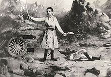
Balbhadra Kunwar, Gurkha commander of the Anglo-Nepalese War
After
Jayayakshya Malla conquered lands that was far larger than what Nepal had been before him, he decided to create a confederation for his sons so that they could rule the nation more efficiently. The Malla confederacy, with more than one ruler overlooking the nation, was more stable than the monarchial rule before. So, the monarchs focussed more on trade, arts and literature than in developing army. By the time Prithvi Narayan Shah had ascended to the throne of Gorkha in 1743. When Prithvi Narayan Shah first attacked Kirtipur in 1745–46, the combined army of Malla confederacy defeated him and killed
Kalu Pandey, the Mul Kaji. Even after the conquest of Kirtipur and
Kantipur, the Malla confederacy fought from Bhaktapur, where, the rulers of all the three states of Malla confederacy surrendered. By 1769 enabled
Prithvi Narayan Shah, the king of
Gorkha, to conquer the valley, forming the foundations for the modern
Kingdom of Nepal. Finally Gorkha conquered Kathmandu and Patan, Bhadgaon, eastern Nepal, and western Nepal between 1768 and 1790. Prithvi Narayan Shah, the first king of united Nepal died in 1775.
In 1767, a request to the
British for help by the traditional valley kings under threat from Gorkha expansion resulted in an ill-equipped and ill-prepared expedition numbering 2,500 led by Captain Kinloch. The expedition was a disaster; the Gorkha army easily overpowered those who had not succumbed to malaria or desertion. This ineffectual British force provided the Gorkhas with firearms and filled them with suspicion, causing some to underestimate their future opponents.
This conquest of the Kathmandu valley was only the beginning of an explosion of Gorkha power throughout the region. The Gorkha armies had overrun all of eastern Nepal by 1773 – by 1788. Gorkha forces had also annexed some western portions of
Sikkim. In the west, all rulers as far as the
Kali River had submitted or been replaced by 1790. Farther west still, the
Kumaon region and its capital
Almora had also succumbed to the Gorkhas.
To the north however, aggressive raids into
Tibet (concerning a long-standing dispute over trade and control of the mountain passes) forced the
Chinese emperor in
Peking to act. In 1792 he sent a huge army, expelling the Nepalese from Tibet to within 5 km (3 mi) of their capital at Kathmandu. Acting regent Bahadur Shah, (Prithvi Naryan’s son), appealed to the British
Governor-General of India,
Francis Rawdon-Hastings, Lord Moira for help. Anxious to avoid confrontation with the Chinese, Lord Moira sent Captain Kirkpatrick as mediator, but before he arrived the war with China had finished. The Nepalese were forced into signing a humiliating treaty revoking their trading privileges in Tibet and requiring them to pay tribute to Peking every 5 years.
The Tibet affair had postponed a previously planned attack on the
Garhwal Kingdom, but by 1803 Raja of
Garhwal Pradyuman Shah had also been defeated. He was killed in the struggle in January 1804, and all his land annexed. Further west, general
Amar Singh Thapa overran lands as far as the
Kangra – the strongest fort in the hill region – and laid siege to it (although by 1809,
Ranjit Singh the ruler of the
Sikh state in the
Punjab, had intervened and driven the Nepalese army east of the
Sutlej river). The British were also expanding their sphere of influence. The recent acquisition of the
Nawab of Awadh's lands by the British East India Company brought the region of
Gorakhpur into the close proximity of the raja of
Palpa – the last remaining independent town within the Gorkha heartlands. Suspicion of the raja’s collusion with the British led first to his imprisonment by the Gorkhas, then to his assassination.
Bhimsen Thapa, Nepalese Prime Minister from 1806 to 1837, installed his own father as governor of Palpa, leading to serious border disputes between the two powers.
These disputes arose because there was no fixed boundary separating the Gorkhas and the British. A border commission imposed on Nepal by the Governor-General failed to solve the problem. Gorkha raids into the flatlands of the
Tarai, a much prized strip of fertile ground separating the Nepalese hill country from India, increased tensions – the British felt their power in the region and their tenuous lines of communication between
Calcutta and the northwest were under threat. Since there was no clear border, confrontation between the powers was inevitable.
As a result of border tensions and ambitious expansionism conflict came to heads in the
Anglo-Nepalese Warof 1814–1816 between the
Kingdom of Nepal (now
Federal Democratic Republic of Nepal) and the
British East India Company. After the successful initial campaign by Ochterlony, however, the Kathmandu durbar failed to ratify the peace agreement signed on 28 November 1815. This reticence to sign soon led to the second campaign. Unsurprisingly, Lord Moira placed Ochterlony in command of the 20,000 strong invasion force of Nepal.
After the decisive Battle of Makwanpur on 28 February 1816 and the fall of the fort of Hariharpur, the Gurkhas were forced to surrender and as a result the
Treaty of Sugauli was ratified on 4 March 1816. Nepal lost Sikkim, the territories of
Kumaon and
Garhwal, and most of the lands of the Tarai; the
British East India Company would pay 200,000 rupees annually to compensate for the loss of income from the Tarai region. However, the Tarai lands had proved difficult to govern and some of them were returned to Nepal later in 1816 and the annual payments abolished.
The Mechi river became the new eastern border and the
Mahakali river the western boundary of Nepal. Kathmandu was also forced to accept a British
Resident, a position that was loathed as it was seen as a symbol of its reduction to client status in relation to the British administration in
Calcutta under the
British Raj.


No comments:
Post a Comment